Cambridge, a region renowned for its cultural landmarks and historic architecture, faced the daunting task of conserving its heritage sites. To address this challenge, the region embarked on an innovative journey, combining the power of geolocated digital twins and drone technology to create comprehensive digital replicas of its historic buildings. This approach facilitated the effective preservation and maintenance of the region's cultural legacy.
Background
Cambridge's historical buildings, cherished for their architectural significance and cultural heritage, were subject to natural wear, environmental factors, and potential structural vulnerabilities. Conventional methods of preservation and restoration lacked the precision and comprehensive insights required for maintaining the authenticity and structural stability of these landmarks. In response, Cambridge embraced advanced technologies, harnessing the capabilities of geolocated digital twins and drones to facilitate informed conservation efforts.
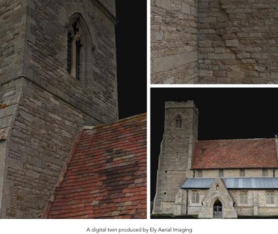
Implementation of Geolocated Digital Twins for Historic Buildings Using Drones
Cambridge collaborated with renowned preservation experts, drone operators, and tech firms specializing in geospatial data analysis to develop a unique approach. Customized drones equipped with specialized cameras and sensors were employed to capture detailed imagery and spatial data of the historic buildings. This data was integrated into a geolocated digital twin platform, allowing for the creation of accurate 3D representations of the buildings, and facilitating in-depth analysis and preservation strategies.
Preservation and Restoration Strategies
The integration of geolocated digital twins facilitated the implementation of tailored preservation and restoration strategies for the historic buildings of Cambridge. The digital twins enabled stakeholders, including preservationists, architects, and historians, to closely examine the structures, identify potential areas of decay or damage, and devise targeted intervention plans. Real-time monitoring and analysis enabled proactive conservation measures, ensuring the long-term preservation of the region's cultural heritage.
Benefits and Impact
The adoption of geolocated digital twins for historic buildings using drones brought about significant benefits for Cambridge, including:
- Enhanced preservation strategies through comprehensive and detailed 3D representations.
- Improved structural assessments, leading to targeted and effective restoration plans.
- Increased public engagement and awareness of the region's cultural heritage.
- Facilitation of informed decision-making for sustainable preservation efforts.
- Promotion of tourism and cultural appreciation, fostering economic growth and community development.
Future Prospects and Sustainability
Cambridge plans to further leverage geolocated digital twins and drone technology to expand its preservation efforts to encompass additional historical sites and cultural landmarks. The region aims to establish a sustainable framework for ongoing conservation and heritage management, ensuring that future generations can continue to appreciate and learn from the rich cultural legacy of Cambridge.
The successful implementation of geolocated digital twins for historic buildings using drones in Cambridge exemplifies the critical role of advanced technologies in preserving and safeguarding our cultural heritage. This case study highlights the transformative potential of combining drone technology with geolocated digital twins, enabling regions to develop tailored preservation strategies, foster cultural appreciation, and ensure the longevity of historical landmarks for generations to come.


