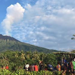
The team, involving 20 researchers from seven countries, used long-range drones kitted out with a range of lightweight sensors to study the Manam volcano - one of the most active volcanoes in Papua New Guinea.
Their findings, published in the journal Science Advances, show how combined measurements from the air, earth and space can be used to understand volcanic contributions to the global carbon cycle, key to sustaining life on Earth.
One of the best ways to detect signs of an impending eruption is to ‘breathalyze’ a volcano by taking regular measurements of volcanic gases. Any change in the ratio of sulfur and carbon dioxide released can warn of an impending eruption. But sampling more remote or hazardous volcanoes like Manam is more challenging.
When the volcano last erupted between 2004 and 2006 the entire island was evacuated - crops were destroyed and water supplies contaminated. The islanders only started to return five years ago.
Previous studies have shown that Manam is one of the world’s biggest emitters of sulphur dioxide, but nothing was known of its CO2 output.
Measuring volcanic CO2 emissions is more challenging because it is already present in high concentrations in the atmosphere. The only way to get accurate readings is to take samples from close to active vents.
Collecting samples on Manam would be incredibly risky - not only is the vent flanked by precarious slopes, the volcano is also unmonitored so there would be little warning if an eruption struck.
Using drones equipped with miniaturised gas sensors, spectrometers and sampling devices the team piloted flights right into the plume emerging from Manam’s vent. The measurements captured gas composition, temperature and humidity in real-time.
The project - Aerial-Based Observations of Volcanic Emissions (ABOVE) – saw the first global collaboration between scientists, remote-sensing specialists, engineers and pilots.
Watch a video and read the full story
Image: View from Baliau village, Manam
Credit: Emma Liu
Reproduced courtesy of the University of Cambridge
